Visualizzazione post con etichetta Ancient Environment. Mostra tutti i post

domenica 2 agosto 2015

CLIMA (mutazioni del) E CIVILTA' (livello di)


Abrupt climate change 

may have 

rocked the cradle of civilization 


Ancient Environment, ArchaeoHeritage, Archaeology, Breakingnews, Climate Change, Earth Science, Egypt, Iran, Iraq, Palaeontology 

New research reveals that some of the earliest civilizations in the Middle East and the Fertile Crescent may have been affected by abrupt climate change. These findings show that while socio-economic factors were traditionally considered to shape ancient human societies in this region, the influence of abrupt climate change should not be underestimated. 


The monumental ziggurat at the ancient city of Ur located in the  Thi Qar province, southern Iraq 
[Credit: The National] 


A team of international scientists led by researchers from the University of Miami (UM) Rosenstiel School of Marine and Atmospheric Science found that during the first half of the last interglacial period known as the Holocene epoch, which began about 12,000 years ago and continues today, the Middle East most likely experienced wetter conditions in comparison with the last 6,000 years, when the conditions were drier and dustier. "Evidence for wet early Holocene was previously found in the Eastern Mediterranean Sea region, North and East African lakes and cave deposits from Southwest Asia, and attributed to higher solar insolation during this period," said Ali Pourmand, assistant professor of marine geosciences at the UM Rosenstiel School, who supervised the project. "Our study, however, is the first of its kind from the interior of West Asia and unique in its resolution and multi-proxy approach." 


The Fertile Crescent 
[Credit: Encyclopædia Britannica] 


The Fertile Crescent, a region in west Asia that extends from Iran and the Arabian Peninsula to the eastern Mediterranean Sea and northern Egypt is one of the most climatically dynamic regions in the world and is widely considered the birthplace of early human civilizations. "The high-resolution nature of this record afforded us the rare opportunity to examine the influence of abrupt climate change on early human societies. We see that transitions in several major civilizations across this region, as evidenced by the available historical and archaeological records, coincided with episodes of high atmospheric dust; higher fluxes of dust are attributed to drier conditions across the region over the last 5,000 years," said Arash Sharifi, Ph.D. candidate at the department of marine geosciences and the lead author of the study. Climate variability during the past 5000 years as told by the concentration of titanium (Ti) in sediment core from Neor Lake, NW Iran. The vertical orange bands denote periods of dry and dusty condition, which correlate with historical records of drought and famine in Iranian Plateau, Mesopotamia and Eastern Mediterranean (brown and black horizontal bars respectively). 


Transition between ruling dynasties (gray arrows) in Iran and North Mesopotamia coincides with the episodes of dry and dusty condition in the region (peaks in Ti intensities) 
[Credit: Arash Sharifi]


The researchers investigated climate variability and changes in paleoenvironmental conditions during the last 13,000 years based on a high-resolution (sub-decadal to centennial) peat record from Neor Lake in Northwest Iran. Abrupt climate changes occur in the span of years to decades. 
The findings appear in the Quaternary Science Reviews.


Source: University of Miami Rosenstiel School of Marine & Atmospheric Science [July 27, 2015]

domenica 12 luglio 2015

Clima ed Evoluzione

Si sa quanto siano stretti i rapporti tra clima ed evoluzione 

dell'Uomo e della Vita in genere. Gli studi (interdisciplinari) 

producono sempre nuove prove scientifiche di questo fatto. 

Ecco un interessante articolo sugli effetti del vulcanismo.


Volcanic eruptions that changed human history 


Ancient Environment, ArchaeoHeritage, Archaeology, Breakingnews, Earth Science, Geology, Palaeontology 


It is well known that large volcanic eruptions contribute to climate variability. 
However, quantifying these contributions has proven challenging due to inconsistencies in both historic atmospheric data observed in ice cores and corresponding temperature variations seen in climate proxies such as tree rings. 


Strong and widespread cooling occurred in the immediate aftermath of large volcanic  eruptions as indicated by ice cores from Greenland [Credit: Michael Sigl] 


Published today in the journal Nature, a new study led by scientists from the Desert Research Institute (DRI) and collaborating international institutions, resolves these inconsistencies with a new reconstruction of the timing and associated radiative forcing of nearly 300 individual volcanic eruptions extending as far back as the early Roman period. "Using new records we are able to show that large volcanic eruptions in the tropics and high latitudes were the dominant drivers of climate variability, responsible for numerous and widespread summer cooling extremes over the past 2,500 years," said the study's lead author Michael Sigl, Ph.D., an assistant research professor at DRI and postdoctoral fellow with the Paul Scherrer Institute in Switzerland.
 "These cooler temperatures were caused by large amounts of volcanic sulfate particles injected into the upper atmosphere," Sigl added, "shielding the Earth's surface from incoming solar radiation." 
The study shows that 15 of the 16 coldest summers recorded between 500 BC and 1,000 AD followed large volcanic eruptions -- with four of the coldest occurring shortly after the largest volcanic events found in record. 
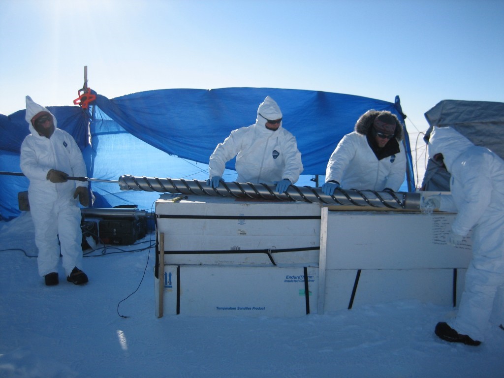
This new reconstruction is derived from more than 20 individual ice cores extracted from ice sheets in Greenland and Antarctica and analyzed for volcanic sulfate primarily using DRI's state-of-the-art, ultra-trace chemical ice-core analytical system. These ice-core records provide a year-by-year history of atmospheric sulfate levels through time. Additional measurements including other chemical parameters were made at collaborating institutions. "We used a new method for producing the timescale," explained Mai Winstrup, Ph.D., a postdoctoral researcher at the University of Washington, Seattle. "Previously, this has been done by hand, but we used a statistical algorithm instead. Together with the state-of-the-art ice core chemistry measurements, this resulted in a more accurate dating of the ice cores." "Using a multidisciplinary approach was key to the success of this project," added Sigl. 


Narrow and distorted tree-rings from long living bristlecone-pines (Snake Mountains,  Nevada, USA), indicating extreme cooling after a large volcanic eruption in 44 BCE,  the year of Julius Cesar's death [Credit: Matthew Salzer]


 In total, a diverse research group of 24 scientists from 18 universities and research institutes in the United States, United Kingdom, Switzerland, Germany, Denmark, and Sweden contributed to this work -- including specialists from the solar, space, climate, and geological sciences, as well as historians. The authors note that identification of new evidence found in both ice cores and corresponding tree rings allowed constraints and verification of their new age scale. "With the discovery of a distinctive signature in the ice-core records from an extra-terrestrial cosmic ray event, we had a critical time marker that we used to significantly improve the dating accuracy of the ice-core chronologies," explained Kees Welten, Ph.D., an associate research chemist from the University of California, Berkeley. A signature from this same event had been identified earlier in various tree-ring chronologies dating to 774-775 Common Era (CE). "Ice-core timescales had been misdated previously by five to ten years during the first millennium leading to inconsistencies in the proposed timing of volcanic eruptions relative to written documentary and tree-ring evidence recording the climatic responses to the same eruptions," explained Francis Ludlow, Ph.D., a postdoctoral fellow from the Yale Climate & Energy Institute. Throughout human history, sustained volcanic cooling effects on climate have triggered crop failures and famines. These events may have also contributed to pandemics and societal decline in agriculture-based communities. Together with Conor Kostick, Ph.D. from the University of Nottingham, Ludlow translated and interpreted ancient and medieval documentary records from China, Babylon (Iraq), and Europe that described unusual atmospheric observations as early as 254 years before Common Era (BCE).
 These phenomena included diminished sunlight, discoloration of the solar disk, the presence of solar coronae, and deeply red twilight skies. 


A freshly drilled ice-core from TUNU, Greenland containing a history of volcanic  eruptions is pushed out of the core barell [Credit: Olivia Maselli] 


Tropical volcanoes and large eruptions in the Northern Hemisphere high latitudes (such as Iceland and North America) -- in 536, 626, and 939 CE, for example -- often caused severe and widespread summer cooling in the Northern Hemisphere by injecting sulfate and ash into the high atmosphere. 
These particles also dimmed the atmosphere over Europe to such an extent that the effect was noted and recorded in independent archives by numerous historical eyewitnesses. Climatic impact was strongest and most persistent after clusters of two or more large eruptions. 
The authors note that their findings also resolve a long-standing debate regarding the causes of one of the most severe climate crises in recent human history, starting with an 18-month "mystery cloud" or dust veil observed in the Mediterranean region beginning in March, 536, the product of a large eruption in the high-latitudes of the Northern Hemisphere. 
The initial cooling was intensified when a second volcano located somewhere in the tropics erupted only four years later. In the aftermath, exceptionally cold summers were observed throughout the Northern Hemisphere. 
This pattern persisted for almost fifteen years, with subsequent crop failures and famines -- likely contributing to the outbreak of the Justinian plague that spread throughout the Eastern Roman Empire from 541 to 543 CE, and which ultimately decimated the human population across Eurasia. "This new reconstruction of volcanic forcing will lead to improved climate model simulations through better quantification of the sensitivity of the climate system to volcanic influences during the past 2,500 years," noted Joe McConnell, Ph.D., a DRI research professor who developed the continuous-flow analysis system used to analyze the ice cores. "As a result," McConnell added, "climate variability observed during more recent times can be put into a multi-millennial perspective -- including time periods such as the Roman Warm Period and the times of significant cultural change such as Great Migration Period of the 6th century in Europe." 
This reconciliation of ice-core records and other records of past environmental change will help define the role that large climatic perturbations may have had in the rise and fall of civilizations throughout human history. "With new high-resolution records emerging from ice cores in Greenland and Antarctica, it will be possible to extend this reconstruction of volcanic forcing probably all the way back into the last Ice Age," said Sigl. 


Source: Desert Research Institute [July 08, 2015]

sabato 14 febbraio 2015

GREEN SAHARA

Rapid end of the Green Sahara 8000 years ago 

9,000 years ago most of the Sahara was not the ultra-arid desert as we know it today. Due to higher precipitation it was covered by large lakes and savannah that were populated by herds of wild game. Scientists from the GEOMAR Helmholtz Centre for Ocean Research Kiel and the Royal Netherlands Institute for Sea Research (NIOZ) now have discovered that vegetation at the end of the Green Sahara disappeared much faster than previously assumed. This probably forced the Neolithic populations to start farming. The study has been published in the international open-access journal PLOS ONE. 


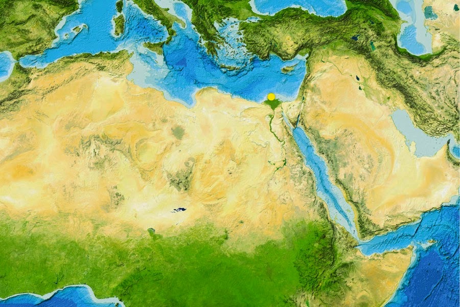
The Sahara is one of the most arid regions in the world. 9000 years ago, it was a green  savannah. Details on the transition could now be reconstructed from samples obtained  off the the mouth of the river Nile in the Mediterranean (yellow dot) [Credit: GEBCO world map 2014] 


Reconstructing the climate of the past is an important tool for scientists to better understand and predict future climate changes. This also applies to the relationships between human activities and environmental changes. In that respect, the Sahara Desert and the Nile valley are key areas since they underwent drastic environmental modification during the course of the last 10,000 years. In the same period, called Holocene by scientists, they were as well the scene of crucial steps of human evolution. At the beginning of the Holocene precipitation in northern Africa was much higher than today. The Sahara was a green savannah where large herds of wild game lived. But in the following millennia the region became one of the most arid areas on Earth. Now researchers from the GEOMAR Helmholtz Centre for Ocean Research Kiel and the Royal Netherlands Institute for Sea Research (NIOZ) have discovered that the vegetation in the Sahara changed much faster than previously assumed. “Though the changes in temperatures and precipitation needed millennia, the vegetation changed dramatically in the course of centuries or even decades”, says Dr. Cecile Blanchet. She is lead author of the study. The initial forcing of the climatic changes during the Holocene was a southward migration of the African monsoon and its associated rain belt. “But there are large regional discrepancies in timing and intensity of the changes, the underlying mechanisms of which remain equivocal”, explains Professor Martin Frank, palaeo-oceanographer at GEOMAR and co-author of the study. During the same epoch, Neolithic human populations also underwent important evolution, such as the initiation of food production and the sedentariness of previously mobile hunter-gatherer populations. 


Approximately 8,000 year-old rock carvings of two giraffes from Dabous, Niger,  documenting that the Sahara was a green fertile Savannah at that time [Credit: Albert Backer/WikiCommons] 


“Providing a more precise timeframe for the wet-dry transition at the end of the African Humid Period is therefore crucial to understand early human-environment relationships”, adds Professor Stefan Schouten from NIOZ, also co-author. For the study Blanchet, Frank and Schouten analyzed a marine sediment core collected off the mouth of the Nile River in 700 metres depth by the German research vessel POSEIDON. Using an innovative combination of geochemical methods they were able to detect traces of the vegetation and eroded soil which had been transported by the river down to the Mediterranean. This allowed them to precisely reconstruct the changes in vegetation, erosion and river runoff in the Nile watershed and their driving mechanisms during the past 9500 years. This high-resolution reconstruction shows that a rapid degradation of the vegetation occurred about 8000 years ago while the overall river runoff only decreased gradually. These asynchronous changes highlight the role of threshold mechanisms in controlling the timing of environmental changes. Furthermore, the rapid shifts in vegetation and sediment source occurred earlier than in other regional records and may have exerted a significant pressure on the Neolithic population in northern Africa. “Maybe these fast changes forced people to use domesticated cattle as a sustainable food resource instead of hunting and gathering”, says Dr. Blanchet. Finally the aridification may have forced most of the population to move to the fertile Nile valley, which ultimately gave rise to the development of the high cultures of the Egyptian Pharaonic Kingdoms. "Of course, further research is needed to confirm this relationship between climate and human evolution. But with our results, we have strong evidence that even a slow climate change can cause rapid and dramatic changes in the environment, which would surely impact human societies" says Dr. Blanchet. 

Source: GEOMAR Helmholtz Centre for ocean research [February 10, 2015] 

giovedì 14 agosto 2014

Influenza della siccità sulle Antiche Civiltà


Ecco un interessante studio dell'Università tedesca di Tubinga  (pubblicato su PNAS), che spiega come l'influenza del Clima sull'Agricoltura abbia rappresentato un fattore chiave 
sulla nascita (e sulla caduta) delle società dell'antico Medio Oriente.

Materiale: 1037 prelievi da 33 aree geografiche di semi di Orzo (Hordeum Vulgaris) di data variabile da 12.000 a 2500 anni fa.

Metodi: studio degli isotopi stabili del Carbonio contenuto nei semi prelevati: quando l'erba dell'orzo riceve acqua in quantità insufficiente durante la crescita, la proporzione di isotopi pesanti di carbonio che fissa è più elevata del normale. 12C e 13C sono stabili per migliaia di anni e possono essere convenientemente misurati e paragonati con le colture moderne della stessa regione.

Scopi: La dimostrazione, solamente iniziata, di come molte aree del Medio Oriente furono pesantemente influenzate, nei rimedi tecnici necessari e che furono ideati dalle popolazioni locali per i propri stanziamenti (irrigazione, canalizzazione) e nelle scelte che presero (in estremi casi, l'abbandono) a seconda della fluttuazione del clima.


Climate change and drought in ancient times 


The influence of climate on agriculture is believed to be a key factor in the rise and fall of societies in the Ancient Near East. 
Dr. Simone Riehl of Tübingen University’s Institute for Archaeological Science and the Senckenberg Center for Human Evolution and Palaeoenvironment has headed an investigation into archaeological finds of grain in order to find out what influence climate had on agriculture in early farming societies. 
Her findings are published in this week’s PNAS – Proceedings of the National Academy of Sciences.


 Archaeological researchers are using stable carbon isotope data from archaeobotanical  barley grains to measure drought stress signals to study climate-related changes  in agricultural production 
[Credit: Simone Riehl, University of Tübingen] 


She and her team analyzed grains of barley up to 12,000 years old from 33 locations across the Fertile Crescent to ascertain if they had had enough water while growing and ripening. 
Riehl found that periods of drought had had noticeable and widely differing effects on agriculture and societies in the Ancient Near East, with settlements finding a variety of ways to deal with the problem.

The 1,037 ancient samples were between 12,000 and 2,500 years old. 

They were compared with modern samples from 13 locations in the former Fertile Crescent. Dr. Riehl and her team measured the grains’ content of two stable carbon isotopes. 
When barley grass gets insufficient water while growing, the proportion of heavier carbon isotopes deposited in its cells will be higher than normal. 
The two isotopes 12C und 13C remain stable for thousands of years and can be measured precisely – giving Simone Riehl and her colleagues reliable information on the availability of water while the plants were growing. 
They found that many settlements were affected by drought linked to major climate fluctuations. 
“Geographic factors and technologies introduced by humans played a big role and influenced societies’ options for development as well as their particular ways of dealing with drought,” says Riehl. 
Her findings indicate that harvests in coastal regions of the northern Levant were little affected by drought; but further inland, drought lead to the need for irrigation or, in extreme cases, abandonment of the settlement. 
The findings give archaeologists clues as to how early agricultural societies dealt with climate fluctuations and differing local environments. 
“They can also help evaluate current conditions in regions with a high risk of crop failures,” Riehl adds.
 The study is part of a German Research Foundation-backed project looking into the conditions under which Ancient Near Eastern societies rose and fell. 

Source: Universitaet Tübingen [August 12, 2014] 

Read more at: http://archaeologynewsnetwork.blogspot.it/2014/08/climate-change-and-drought-in-ancient.html?utm_source=feedburner&utm_medium=feed&utm_campaign=Feed:+TheArchaeologyNewsNetwork+(The+Archaeology+News+Network)#.U-xKiCh7DfU
Follow us: @ArchaeoNewsNet on Twitter | groups/thearchaeologynewsnetwork/ on Facebook

sabato 17 maggio 2014

Clima e Storia, ancora

Climate change caused empire's fall, tree rings reveal 


A handful of tree ring samples stored in an old cigar box have shed unexpected light on the ancient world, thanks to research by archaeologist Sturt W. Manning and collaborators at Cornell, Arizona, Chicago, Oxford and Vienna, forthcoming in the June issue of the Journal of Archaeological Science. 


A view of Ipi-ha-ishutef’s coffin when originally sampled in 1938 
[Credit: Cornell University] 


The samples were taken from an Egyptian coffin; Manning also examined wood from funeral boats buried near the pyramid of Sesostris III. He used a technique called “dendro radiocarbon wiggle matching,” which calibrates radiocarbon isotopes found in the sample tree rings with patterns known from other places in the world that have already identified chronologies, such as the long European oak chronology or the bristle cone pine trees of North America.

Because the dating was so precise – plus or minus about 10 years – it helps confirm that the “higher” Egyptian chronology for the time period is correct, a question scholars have hotly debated.

But the samples also showed a small, unusual anomaly following the year 2200 B.C. Paleoclimate research has suggested a major short-term arid event about this time. 


The coffin of Ipi-ha-ishutef showing details of the decorations on the walls. This is the coffin tree ring samples were taken from [Credit: S. Cristanetti, A. Whyte/University of Chicago’s Oriental Institute] 


“This radiocarbon anomaly would be explained by a change in growing season, i.e., climate, dating to exactly this arid period of time,” says Manning. 
“We’re showing that radiocarbon and these archaeological objects can confirm and in some 
ways better date a key climate episode.”

That climate episode, says Manning, had major political 

implications. There was just enough change in the climate to 

upset food resources and other infrastructure, which is likely 

what led to the collapse of the Akkadian Empire and affected 

the Old Kingdom of Egypt and a number of other 

civilizations, he says. “The tree rings show the kind of rapid 

climate change that we and policymakers fear,” says 

Manning. “This record shows that climate change doesn’t 

have to be as catastrophic as an Ice Age to wreak havoc. 

We’re in exactly the same situation as the Akkadians: If 

something suddenly undid the standard food production 

model in large areas of the U.S. it would be a disaster.” 


Author: Linda B. Glaser  

Source: Cornell University [May 15, 2014]

Read more at: http://archaeologynewsnetwork.blogspot.it/2014/05/climate-change-caused-empires-fall-tree.html?utm_source=feedburner&utm_medium=feed&utm_campaign=Feed:+TheArchaeologyNewsNetwork+(The+Archaeology+News+Network)#.U3ZDyih7DfW
Follow us: @ArchaeoNewsNet on Twitter | groups/thearchaeologynewsnetwork/ on Facebook


venerdì 9 maggio 2014

Tree ring Divergence

Arctic study sheds light on tree-ring divergence

 problem 


  Changes in tree-ring density in the Arctic may be evidence of changes in light intensity during the trees' growth, according to a new study by San Francisco State University researcher Alexander Stine. 


Changes in tree-ring density in the Arctic may be evidence of changes in light intensity  during the trees' growth, according to a new study by San Francisco State University  researcher Alexander Stine
 [Credit: Victor Zastolfskiy/Fotolia]


 The finding has direct implications for the tree-ring "divergence problem," a phenomenon that has received considerable media attention but has been widely misinterpreted, said Stine, an assistant professor of Earth & climate sciences. 

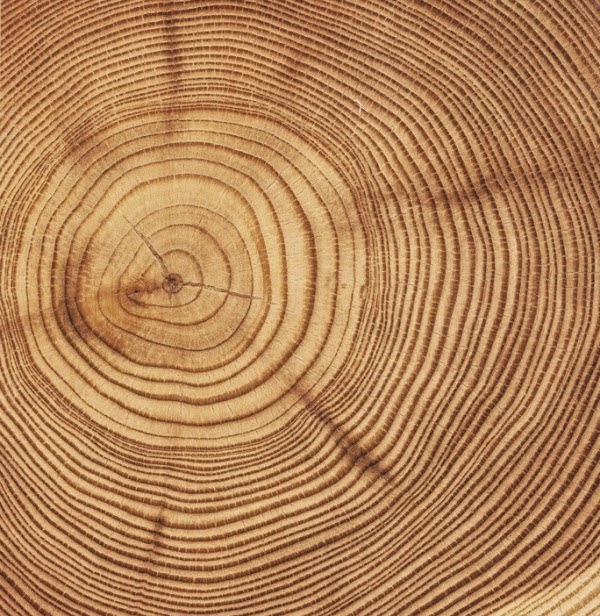
Tree rings consist of a low density ring, which forms early in the growing season, and a high density ring that forms late in the growing season. 

In colder parts of the world, the dense latewood rings tend to be denser during warm years. Temperature records inferred from Arctic tree rings do a good job of tracking temperature up until the 1960s, but subsequent Arctic tree-ring densities did not keep pace with increases in temperature, a discrepancy that is called the divergence problem. 

Climate scientists have been aware of the divergence problem for some time, and it was mentioned in the emails from the Climatic Research Unit at the University of East Anglia, where it became the focus of attention during the 2009 "Climategate" controversy. 

The divergence is not a problem for understanding modern climate change in the Arctic, Stine explained, "because we have thermometers and those thermometers tell us it's warming. 
But it's a problem because if we want to use these tree rings as a proxy for temperatures of the past, we need to make sure that we understand what's happening now." 
Stine sees the new findings as the "bright side" of the divergence problem, one which he hopes will lead to a more informed discussion about climate change. 
"We could learn more about past variations in light intensity at the Earth's surface, and we may be able to deepen our understanding of both trees and climate." 


Each circle represents one of the tree-ring chronologies used in this study. Chronologies  are distinguished according to being from sectors that are cloudy and cool  (dark green), cloudy and warm (light green), clear and cool (dark brown), and clear and  warm (light brown) 
[Credit:  A. R. Stine & P. Huybers, Nature Communications] 


With his colleague Peter Huybers at Harvard University, Stine set out to understand why tree-ring density was declining in the Arctic. One possible explanation, the two thought, might be changes in light intensity that affected the trees' ability to grow. 

Starting in the 1960s, the amount of sunlight reaching the Earth's surface has declined. Scientists debate the cause of this "global dimming," with many scientists attributing it to pollution particles injected into the atmosphere by human activity that deflect incoming sunlight. 
The researchers tested whether global dimming might be responsible for the decline in tree-ring density in the Arctic. This idea had been proposed in the past, but scientists had not been able to test the hypothesis. 
"It's very hard to distinguish a record that's controlled by temperature from one that's controlled by light, because light and temperature tend to vary together. 
Sunnier days are usually warmer," Stine added. To get around this challenge, the researchers took advantage of the fact that there are regional variations in cloud cover and light availability throughout the Arctic, allowing them to compare trees that grew in the brightest and darkest areas but in comparable temperature ranges. They found that divergence was largest in the darkest parts of the Arctic, where changes in light should have the largest effect. 
The researchers used changes in tree-ring density following volcanic eruptions to confirm the findings. 
Major volcanic events such as the 1991 eruption of Mount Pinatubo in the Philippines also have spewed tons of light-scattering sulfur dioxide particles into the atmosphere, decreasing the amount of sunlight reaching the surface. 
Their analysis, published in Nature Communications, for seven different tree species suggests variations in light intensity caused by volcanic eruptions and global dimming both affect tree-ring density, and this impact is greatest in the darkest Arctic regions.
In the brightest areas, the divergence problem essentially disappears, and tree-ring density is most closely linked to temperature instead. 
Stine said the findings could have implications for geoengineering proposals that would pump more aerosol particles into the atmosphere as a way to block sunlight and potentially cool a warming planet. The tree-ring study suggests that Arctic trees might not grow as much -- and thus not soak up as much atmosphere-polluting carbon -- under such a plan. 

Source: San Francisco State University [May 07, 2014]

domenica 2 marzo 2014

Beringia

Il 'ponte' della Beringia, che un tempo univa l'attuale Siberia all'Alaska non era solo ghiaccio: era anche terra solida, bassa e cespugliosa, sulla quale si soffermarono - per un lungo periodo, forse anche 10.000 anni - alcune popolazioni. Non esistono prove archeologiche perché la Beringia si trova ora tutta sotto il livello del mare. Ma anche in assenza di queste, gli scienziati si basano su prove genetico-ambientali per le loro affermazioni (carotaggi marini ed in Alaska, con ritrovamenti di pollini, resti di insetti e piante). Tra i discendenti di queste popolazioni sarebbero gli attuali Inuit.
Insomma: sbiadisce l'immagine della Beringia-tundra erbosa e inizia ad affermarsi l'immagine di una Beringia verde, con cespugli e persino alberi e presenza di numerosi 'refugia' per gli esseri viventi.

10,000 years on the Bering Land Bridge 


Genetic and environmental evidence indicates that after the ancestors of Native Americans left Asia, they spent 10,000 years in shrubby lowlands on a broad land bridge that once linked Siberia and Alaska. Archaeological evidence is lacking because it drowned beneath the Bering Sea when sea levels rose. 


Canadian Inuit dogs pull a sled using traditional harnesses in February 2010 in Iqaluit, Canada.
 Inuit people are among the many descendants of the people now believed to have lingered for 10,000 years in the Bering land bridge, or Beringia [Credit: AP/Rob Gillies] 


University of Utah anthropologist Dennis O'Rourke and two colleagues make that argument in the Friday, Feb. 28, issue of the journal Science. They seek to reconcile existing genetic and paleoenvironmental evidence for human habitation on the Bering land bridge -- also called Beringia -- with an absence of archaeological evidence. 
O'Rourke says cumulative evidence indicates the ancestors of Native Americans lived on the Bering land bridge "in the neighborhood of 10,000 years," from roughly 25,000 years ago until they began moving into the Americas about 15,000 years ago once glacial ice sheets melted and opened migration routes. O'Rourke co-authored the Science Perspective column -- titled "Out of Beringia?" -- with archaeologist John Hoffecker of the University of Colorado at Boulder, and Scott Elias, a paleoecologist at the University of London. Perspective columns in Science don't feature research by the authors, but instead are meant to highlight and provide context for exciting new research in a field or across fields. "Nobody disputes that the ancestors of Native American peoples came from Asia over the coast and interior of the land bridge" during an ice age called the "last glacial maximum," which lasted from 28,000 to at least 18,000 years ago, O'Rourke says, The ice sheets extended south into the Pacific Northwest, Wyoming, Wisconsin and Ohio. Large expanses of Siberia and Beringia were cold but lacked glaciers. The absence of archaeological sites and the inhospitable nature of open, treeless landscape known as tundra steppe mean that "archaeologists have not given much credence to the idea there was a population that lived on the Bering land bridge for thousands of years," he adds. O'Rourke and colleagues say that in recent years, paleoecologists -- scientists who study ancient environments -- drilled sediment cores from the Bering Sea and Alaskan bogs. Those sediments contain pollen, plant and insect fossils, suggesting the Bering land bridge wasn't just barren, grassy tundra steppe but was dotted by "refugia" or refuges where there were brushy shrubs and even trees such as spruce, birch, willow and alder. "We're putting it together with the archaeology and genetics that speak to American origins and saying, look, there was an environment with trees and shrubs that was very different than the open, grassy steppe. It was an area where people could have had resources, lived and persisted through the last glacial maximum in Beringia," O'Rourke says. "That may have been critical for the people to subsist because they would have had wood for construction and for fires. Otherwise, they would have had to use bone, which is difficult to burn." A Frozen, Isolated Dawn for the Earliest Americans During the last glacial maximum, thick glacial ice sheets extended south into what now is the northern United States, sea levels dropped some 400 feet, O'Rourke says. As the glaciers melted, sea levels began to rise, reaching current levels 6,000 years ago. During the long glacial period, Siberia and Alaska were linked by the Bering land bridge, which contrary to the name's implication, really was a huge swath of land north, between and south of Siberia and Alaska, at the present sites of the Chukchi Sea, the Bering Strait and the Bering Sea, respectively. 


This map shows the outlines of modern Siberia (left) and Alaska (right) with dashed lines. The broader area in darker green (now covered by ocean) represents the Bering land bridge near the end of the last glacial maximum, a period that lasted from 28,000 to 18,000 years ago when sea levels were low and ice sheets extended south into what is now the northern part of the lower 48 states. University of Utah anthropologist Dennis O'Rourke argues in the Feb. 28 issue of the journal Science that the ancestors of Native Americans migrated from Asia onto the Bering land bridge or "Beringia" some 25,000 years ago and spent 10,000 years there until they began moving into the Americas 15,000 years ago as the ice sheets melted [Credit: Wlliam Manley, Institute of Arctic and Alpine Research, University of Colorado] 


At its largest extent, Beringia measured as much as 1,000 miles from north to south and as much as 3,000 miles from Siberia's Verkoyansk Range east to the Mackenzie River in in Canada. The theory that humans inhabited the Bering land bridge for some 10,000 years "helps explain how a Native American genome (genetic blueprint) became separate from its Asian ancestor," O'Rourke says. "At some point, the genetic blueprint that defines Native American populations had to become distinct from that Asian ancestry," he explains. "The only way to do that was for the population to be isolated. Most of us don't believe that isolation took place in Siberia because we don't see a place where a population could be sufficiently isolated. It would always have been in contact with other Asian groups on its periphery." "But if there were these shrub-tundra refugia in central Beringia, that provided a place where isolation could occur" due to distance from Siberia, O'Rourke says. Genetic and Paleoenvironmental Evidence O'Rourke and colleagues point to a study of mitochondrial DNA -- genetic information passed by mothers -- sampled from Native Americans throughout the Americas. The study found that the unique genome or genetic blueprint of Native Americans arose sometime before 25,000 years ago but didn't spread through the Americas until about 15,000 years ago. "This result indicated that a substantial population existed somewhere, in isolation from the rest of Asia, while its genome differentiated from the parental Asian genome," O'Rourke says. "The researchers suggested Beringia as the location for this isolated population, and suggested it existed there for several thousand years before members of the population migrated southward into the rest of North and, ultimately, South America as retreating glaciers provided routes for southern migration." "Several other genetic-genomic analyses of Native American populations have resulted in similar conclusions," he adds. "For a long time, many of us thought the land bridge was a uniform tundra-steppe environment" -- a broad windswept grassland devoid of shrubs and trees, O'Rourke says. But in recent years, sediment cores drilled in the Bering Sea and along the Alaskan coast -- the now-submerged lowlands of Beringia -- found pollens of trees and shrubs. That "suggests Beringia was not a uniform tundra-steppe environment, but a patchwork of environments, including substantial areas of lowland shrub tundra," O'Rourke says. "These shrub-tundra areas were likely refugia for a population that would be invisible archaeologically, since the former Beringian lowlands are now submerged." "Large herd animals like bison or mammoths likely lived on the highland steppe tundra because they graze. Many smaller animals, birds, elk and moose (which browse shrubs instead of grazing on grass) would have been in the shrub tundra," he adds. Other research indicates "that much of Beringia -- particularly the lowlands -- appears to have had average summer temperatures nearly identical (or only slightly cooler in some regions) to those in the region today," O'Rourke says. "The local environments likely were not as daunting as many have assumed for years. They probably hunkered down pretty good in the winter though. It would have been cold." The idea that rising sea levels covered evidence of human migration to the Americas has long been cited by researchers studying how early Native Americans moved south along the Pacific coast as the glaciers receded and sea levels rose. O'Rourke says the idea hasn't been used before to explain the scarcity of archaeological sites in Alaska and Siberia, which were highlands when the land bridge was exposed. But O'Rourke and his colleagues say archaeological sites must be found in Beringia if the long human layover there is to be confirmed. Although most such sites are underwater, some evidence of human habitation in shrub tundra might remain above sea level in low-lying portions of Alaska and eastern Chukotka (in Russia)." 


Source: University of Utah [February 27, 2014] 

Read more at: http://archaeologynewsnetwork.blogspot.it/2014/02/10000-years-on-bering-land-bridge.html?utm_source=feedburner&utm_medium=feed&utm_campaign=Feed:+TheArchaeologyNewsNetwork+(The+Archaeology+News+Network)#.UxNvd4uLdCB
Follow us: @ArchaeoNewsNet on Twitter | groups/thearchaeologynewsnetwork/ on Facebook