Visualizzazione post con etichetta Earth Science. Mostra tutti i post

domenica 2 agosto 2015

CLIMA (mutazioni del) E CIVILTA' (livello di)


Abrupt climate change 

may have 

rocked the cradle of civilization 


Ancient Environment, ArchaeoHeritage, Archaeology, Breakingnews, Climate Change, Earth Science, Egypt, Iran, Iraq, Palaeontology 

New research reveals that some of the earliest civilizations in the Middle East and the Fertile Crescent may have been affected by abrupt climate change. These findings show that while socio-economic factors were traditionally considered to shape ancient human societies in this region, the influence of abrupt climate change should not be underestimated. 


The monumental ziggurat at the ancient city of Ur located in the  Thi Qar province, southern Iraq 
[Credit: The National] 


A team of international scientists led by researchers from the University of Miami (UM) Rosenstiel School of Marine and Atmospheric Science found that during the first half of the last interglacial period known as the Holocene epoch, which began about 12,000 years ago and continues today, the Middle East most likely experienced wetter conditions in comparison with the last 6,000 years, when the conditions were drier and dustier. "Evidence for wet early Holocene was previously found in the Eastern Mediterranean Sea region, North and East African lakes and cave deposits from Southwest Asia, and attributed to higher solar insolation during this period," said Ali Pourmand, assistant professor of marine geosciences at the UM Rosenstiel School, who supervised the project. "Our study, however, is the first of its kind from the interior of West Asia and unique in its resolution and multi-proxy approach." 


The Fertile Crescent 
[Credit: Encyclopædia Britannica] 


The Fertile Crescent, a region in west Asia that extends from Iran and the Arabian Peninsula to the eastern Mediterranean Sea and northern Egypt is one of the most climatically dynamic regions in the world and is widely considered the birthplace of early human civilizations. "The high-resolution nature of this record afforded us the rare opportunity to examine the influence of abrupt climate change on early human societies. We see that transitions in several major civilizations across this region, as evidenced by the available historical and archaeological records, coincided with episodes of high atmospheric dust; higher fluxes of dust are attributed to drier conditions across the region over the last 5,000 years," said Arash Sharifi, Ph.D. candidate at the department of marine geosciences and the lead author of the study. Climate variability during the past 5000 years as told by the concentration of titanium (Ti) in sediment core from Neor Lake, NW Iran. The vertical orange bands denote periods of dry and dusty condition, which correlate with historical records of drought and famine in Iranian Plateau, Mesopotamia and Eastern Mediterranean (brown and black horizontal bars respectively). 


Transition between ruling dynasties (gray arrows) in Iran and North Mesopotamia coincides with the episodes of dry and dusty condition in the region (peaks in Ti intensities) 
[Credit: Arash Sharifi]


The researchers investigated climate variability and changes in paleoenvironmental conditions during the last 13,000 years based on a high-resolution (sub-decadal to centennial) peat record from Neor Lake in Northwest Iran. Abrupt climate changes occur in the span of years to decades. 
The findings appear in the Quaternary Science Reviews.


Source: University of Miami Rosenstiel School of Marine & Atmospheric Science [July 27, 2015]

domenica 12 luglio 2015

Clima ed Evoluzione

Si sa quanto siano stretti i rapporti tra clima ed evoluzione 

dell'Uomo e della Vita in genere. Gli studi (interdisciplinari) 

producono sempre nuove prove scientifiche di questo fatto. 

Ecco un interessante articolo sugli effetti del vulcanismo.


Volcanic eruptions that changed human history 


Ancient Environment, ArchaeoHeritage, Archaeology, Breakingnews, Earth Science, Geology, Palaeontology 


It is well known that large volcanic eruptions contribute to climate variability. 
However, quantifying these contributions has proven challenging due to inconsistencies in both historic atmospheric data observed in ice cores and corresponding temperature variations seen in climate proxies such as tree rings. 


Strong and widespread cooling occurred in the immediate aftermath of large volcanic  eruptions as indicated by ice cores from Greenland [Credit: Michael Sigl] 


Published today in the journal Nature, a new study led by scientists from the Desert Research Institute (DRI) and collaborating international institutions, resolves these inconsistencies with a new reconstruction of the timing and associated radiative forcing of nearly 300 individual volcanic eruptions extending as far back as the early Roman period. "Using new records we are able to show that large volcanic eruptions in the tropics and high latitudes were the dominant drivers of climate variability, responsible for numerous and widespread summer cooling extremes over the past 2,500 years," said the study's lead author Michael Sigl, Ph.D., an assistant research professor at DRI and postdoctoral fellow with the Paul Scherrer Institute in Switzerland.
 "These cooler temperatures were caused by large amounts of volcanic sulfate particles injected into the upper atmosphere," Sigl added, "shielding the Earth's surface from incoming solar radiation." 
The study shows that 15 of the 16 coldest summers recorded between 500 BC and 1,000 AD followed large volcanic eruptions -- with four of the coldest occurring shortly after the largest volcanic events found in record. 
This new reconstruction is derived from more than 20 individual ice cores extracted from ice sheets in Greenland and Antarctica and analyzed for volcanic sulfate primarily using DRI's state-of-the-art, ultra-trace chemical ice-core analytical system. These ice-core records provide a year-by-year history of atmospheric sulfate levels through time. Additional measurements including other chemical parameters were made at collaborating institutions. "We used a new method for producing the timescale," explained Mai Winstrup, Ph.D., a postdoctoral researcher at the University of Washington, Seattle. "Previously, this has been done by hand, but we used a statistical algorithm instead. Together with the state-of-the-art ice core chemistry measurements, this resulted in a more accurate dating of the ice cores." "Using a multidisciplinary approach was key to the success of this project," added Sigl. 


Narrow and distorted tree-rings from long living bristlecone-pines (Snake Mountains,  Nevada, USA), indicating extreme cooling after a large volcanic eruption in 44 BCE,  the year of Julius Cesar's death [Credit: Matthew Salzer]


 In total, a diverse research group of 24 scientists from 18 universities and research institutes in the United States, United Kingdom, Switzerland, Germany, Denmark, and Sweden contributed to this work -- including specialists from the solar, space, climate, and geological sciences, as well as historians. The authors note that identification of new evidence found in both ice cores and corresponding tree rings allowed constraints and verification of their new age scale. "With the discovery of a distinctive signature in the ice-core records from an extra-terrestrial cosmic ray event, we had a critical time marker that we used to significantly improve the dating accuracy of the ice-core chronologies," explained Kees Welten, Ph.D., an associate research chemist from the University of California, Berkeley. A signature from this same event had been identified earlier in various tree-ring chronologies dating to 774-775 Common Era (CE). "Ice-core timescales had been misdated previously by five to ten years during the first millennium leading to inconsistencies in the proposed timing of volcanic eruptions relative to written documentary and tree-ring evidence recording the climatic responses to the same eruptions," explained Francis Ludlow, Ph.D., a postdoctoral fellow from the Yale Climate & Energy Institute. Throughout human history, sustained volcanic cooling effects on climate have triggered crop failures and famines. These events may have also contributed to pandemics and societal decline in agriculture-based communities. Together with Conor Kostick, Ph.D. from the University of Nottingham, Ludlow translated and interpreted ancient and medieval documentary records from China, Babylon (Iraq), and Europe that described unusual atmospheric observations as early as 254 years before Common Era (BCE).
 These phenomena included diminished sunlight, discoloration of the solar disk, the presence of solar coronae, and deeply red twilight skies. 


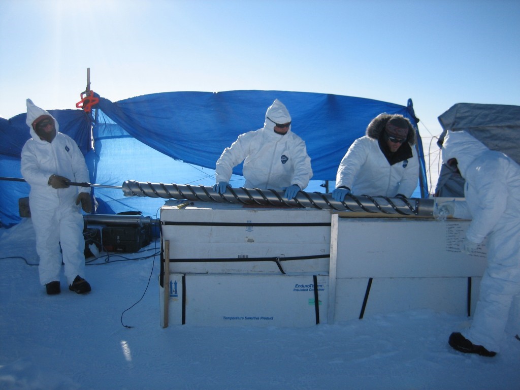
A freshly drilled ice-core from TUNU, Greenland containing a history of volcanic  eruptions is pushed out of the core barell [Credit: Olivia Maselli] 


Tropical volcanoes and large eruptions in the Northern Hemisphere high latitudes (such as Iceland and North America) -- in 536, 626, and 939 CE, for example -- often caused severe and widespread summer cooling in the Northern Hemisphere by injecting sulfate and ash into the high atmosphere. 
These particles also dimmed the atmosphere over Europe to such an extent that the effect was noted and recorded in independent archives by numerous historical eyewitnesses. Climatic impact was strongest and most persistent after clusters of two or more large eruptions. 
The authors note that their findings also resolve a long-standing debate regarding the causes of one of the most severe climate crises in recent human history, starting with an 18-month "mystery cloud" or dust veil observed in the Mediterranean region beginning in March, 536, the product of a large eruption in the high-latitudes of the Northern Hemisphere. 
The initial cooling was intensified when a second volcano located somewhere in the tropics erupted only four years later. In the aftermath, exceptionally cold summers were observed throughout the Northern Hemisphere. 
This pattern persisted for almost fifteen years, with subsequent crop failures and famines -- likely contributing to the outbreak of the Justinian plague that spread throughout the Eastern Roman Empire from 541 to 543 CE, and which ultimately decimated the human population across Eurasia. "This new reconstruction of volcanic forcing will lead to improved climate model simulations through better quantification of the sensitivity of the climate system to volcanic influences during the past 2,500 years," noted Joe McConnell, Ph.D., a DRI research professor who developed the continuous-flow analysis system used to analyze the ice cores. "As a result," McConnell added, "climate variability observed during more recent times can be put into a multi-millennial perspective -- including time periods such as the Roman Warm Period and the times of significant cultural change such as Great Migration Period of the 6th century in Europe." 
This reconciliation of ice-core records and other records of past environmental change will help define the role that large climatic perturbations may have had in the rise and fall of civilizations throughout human history. "With new high-resolution records emerging from ice cores in Greenland and Antarctica, it will be possible to extend this reconstruction of volcanic forcing probably all the way back into the last Ice Age," said Sigl. 


Source: Desert Research Institute [July 08, 2015]

lunedì 23 marzo 2015

IGNINBRITE CAMPANA

Un articolo interessante, che cerca di individuare una 

possibile spiegazione per la scomparsa del Neanderthal. I 

ricercatori avvertono però che una grande eruzione in 

Italia (responsabile di un raffreddamento climatico 

globale) avrebbe più probabilmente solo dato un colpo di 

grazia ad una specie già in serio pericolo biologico 

d'estinzione per la propria scarsità numerica (un 'collo di 

bottiglia') e che già stava soccombendo alla più 

competitiva specie cui l'uomo moderno appartiene... 

D'altro canto, sembrerebbe strano che una temperatura più 

rigida - da sola - potesse mettere in difficoltà proprio il 

Neanderthal, che per le temperature fredde era 

attrezzatissimo.

Lo studio entra nei risvolti quantitativi e nell'estensione 

geografica della diminuzione di temperatura. Sembra che 

l'entità della diminuzione fosse - in Europa Occidentale - 

solo di 2/4 gradi e che quindi la maggiore differenza di 

temperatura (con le maggiori difficoltà ambientali) abbia 

'bipassato' proprio le zone in cui i Neanderthal resistettero 

più a lungo. Le zone geografiche più colpite sarebbero state 

l'Asia e l'Europa Orientale. 

Quindi, sostanzialmente, lo studio è negativo: la 

conclusione è che non fu l'abbassamento di temperatura ad 

eliminare il Neanderthal. Ma i ricercatori ritengono di 

avere sottolineato ancora una volta quanto sia sempre 

stato determinante il clima per tutti gli esseri viventi ed in 

quale misura l'uomo anatomicamente si sia sempre 

dimostrato più adattabile del Neanderthal alle variazioni 

ambientali. 

Did a volcanic cataclysm 

40,000 years ago trigger the 

final demise of the Neanderthals? 

The Campanian Ignimbrite (CI) eruption in Italy 40,000 years ago was one of the largest volcanic cataclysms in Europe and injected a significant amount of sulfur-dioxide (SO2) into the stratosphere. 
Scientists have long debated whether this eruption contributed to the final extinction of the Neanderthals. 


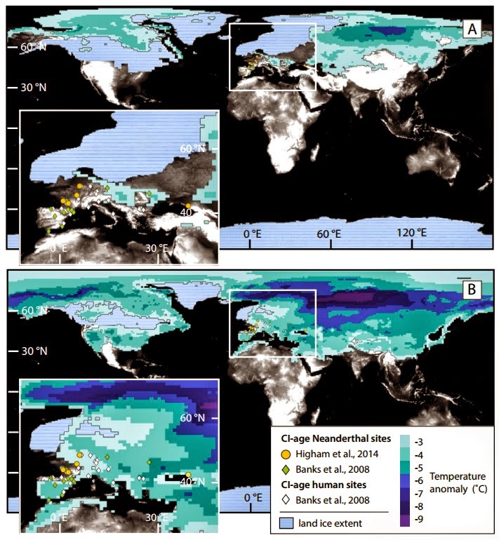
This new study by Benjamin A. Black and colleagues tests this hypothesis with a sophisticated climate model. Figure 4 in B.A. Black et al.: This image shows annually averaged temperature  anomalies in excess of 3°C for the first year after the Campanian Ignimbrite (CI)  eruption compared with spatial distribution of hominin sites with radiocarbon ages  close to that of the eruption 
[Credit: B.A. Black et al. and the journal Geology] 


Black and colleagues write that the CI eruption approximately coincided with the final decline of Neanderthals as well as with dramatic territorial and cultural advances among anatomically modern humans. 
Because of this, the roles of climate, hominin competition, and volcanic sulfur cooling and acid deposition have been vigorously debated as causes of Neanderthal extinction.

They point out, however, that the decline of Neanderthals in Europe began well before the CI eruption: "Radiocarbon dating has shown that at the time of the CI eruption, anatomically modern humans had already arrived in Europe, and the range of Neanderthals had steadily diminished. 
Work at five sites in the Mediterranean indicates that anatomically modern humans were established in these locations by then as well." 
"While the precise implications of the CI eruption for cultures and livelihoods are best understood in the context of archaeological data sets," write Black and colleagues, the results of their study quantitatively describe the magnitude and distribution of the volcanic cooling and acid deposition that ancient hominin communities experienced coincident with the final decline of the Neanderthals. 

In their climate simulations, Black and colleagues found that the largest temperature decreases after the eruption occurred in Eastern Europe and Asia and sidestepped the areas where the final Neanderthal populations were living (Western Europe).

Therefore, the authors conclude that the eruption was probably insufficient to trigger Neanderthal extinction.

However, the abrupt cold spell that followed the eruption would still have significantly impacted day-to-day life for Neanderthals and early humans in Europe.

Black and colleagues point out that temperatures in Western Europe would have decreased by an average of 2 to 4 degrees Celsius during the year following the eruption.

These unusual conditions, they write, may have directly influenced survival and day-to-day life for Neanderthals and anatomically modern humans alike, and emphasize the resilience of anatomically modern humans in the face of abrupt and adverse changes in the environment. 

Source: Geological Society of America [March 20, 2015]


sabato 14 febbraio 2015

GREEN SAHARA

Rapid end of the Green Sahara 8000 years ago 

9,000 years ago most of the Sahara was not the ultra-arid desert as we know it today. Due to higher precipitation it was covered by large lakes and savannah that were populated by herds of wild game. Scientists from the GEOMAR Helmholtz Centre for Ocean Research Kiel and the Royal Netherlands Institute for Sea Research (NIOZ) now have discovered that vegetation at the end of the Green Sahara disappeared much faster than previously assumed. This probably forced the Neolithic populations to start farming. The study has been published in the international open-access journal PLOS ONE. 


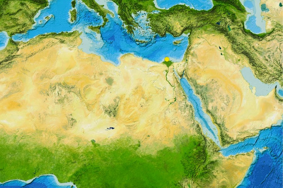
The Sahara is one of the most arid regions in the world. 9000 years ago, it was a green  savannah. Details on the transition could now be reconstructed from samples obtained  off the the mouth of the river Nile in the Mediterranean (yellow dot) [Credit: GEBCO world map 2014] 


Reconstructing the climate of the past is an important tool for scientists to better understand and predict future climate changes. This also applies to the relationships between human activities and environmental changes. In that respect, the Sahara Desert and the Nile valley are key areas since they underwent drastic environmental modification during the course of the last 10,000 years. In the same period, called Holocene by scientists, they were as well the scene of crucial steps of human evolution. At the beginning of the Holocene precipitation in northern Africa was much higher than today. The Sahara was a green savannah where large herds of wild game lived. But in the following millennia the region became one of the most arid areas on Earth. Now researchers from the GEOMAR Helmholtz Centre for Ocean Research Kiel and the Royal Netherlands Institute for Sea Research (NIOZ) have discovered that the vegetation in the Sahara changed much faster than previously assumed. “Though the changes in temperatures and precipitation needed millennia, the vegetation changed dramatically in the course of centuries or even decades”, says Dr. Cecile Blanchet. She is lead author of the study. The initial forcing of the climatic changes during the Holocene was a southward migration of the African monsoon and its associated rain belt. “But there are large regional discrepancies in timing and intensity of the changes, the underlying mechanisms of which remain equivocal”, explains Professor Martin Frank, palaeo-oceanographer at GEOMAR and co-author of the study. During the same epoch, Neolithic human populations also underwent important evolution, such as the initiation of food production and the sedentariness of previously mobile hunter-gatherer populations. 


Approximately 8,000 year-old rock carvings of two giraffes from Dabous, Niger,  documenting that the Sahara was a green fertile Savannah at that time [Credit: Albert Backer/WikiCommons] 


“Providing a more precise timeframe for the wet-dry transition at the end of the African Humid Period is therefore crucial to understand early human-environment relationships”, adds Professor Stefan Schouten from NIOZ, also co-author. For the study Blanchet, Frank and Schouten analyzed a marine sediment core collected off the mouth of the Nile River in 700 metres depth by the German research vessel POSEIDON. Using an innovative combination of geochemical methods they were able to detect traces of the vegetation and eroded soil which had been transported by the river down to the Mediterranean. This allowed them to precisely reconstruct the changes in vegetation, erosion and river runoff in the Nile watershed and their driving mechanisms during the past 9500 years. This high-resolution reconstruction shows that a rapid degradation of the vegetation occurred about 8000 years ago while the overall river runoff only decreased gradually. These asynchronous changes highlight the role of threshold mechanisms in controlling the timing of environmental changes. Furthermore, the rapid shifts in vegetation and sediment source occurred earlier than in other regional records and may have exerted a significant pressure on the Neolithic population in northern Africa. “Maybe these fast changes forced people to use domesticated cattle as a sustainable food resource instead of hunting and gathering”, says Dr. Blanchet. Finally the aridification may have forced most of the population to move to the fertile Nile valley, which ultimately gave rise to the development of the high cultures of the Egyptian Pharaonic Kingdoms. "Of course, further research is needed to confirm this relationship between climate and human evolution. But with our results, we have strong evidence that even a slow climate change can cause rapid and dramatic changes in the environment, which would surely impact human societies" says Dr. Blanchet. 

Source: GEOMAR Helmholtz Centre for ocean research [February 10, 2015] 

venerdì 9 maggio 2014

Tree ring Divergence

Arctic study sheds light on tree-ring divergence

 problem 


  Changes in tree-ring density in the Arctic may be evidence of changes in light intensity during the trees' growth, according to a new study by San Francisco State University researcher Alexander Stine. 


Changes in tree-ring density in the Arctic may be evidence of changes in light intensity  during the trees' growth, according to a new study by San Francisco State University  researcher Alexander Stine
 [Credit: Victor Zastolfskiy/Fotolia]


 The finding has direct implications for the tree-ring "divergence problem," a phenomenon that has received considerable media attention but has been widely misinterpreted, said Stine, an assistant professor of Earth & climate sciences. 

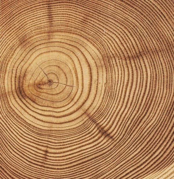
Tree rings consist of a low density ring, which forms early in the growing season, and a high density ring that forms late in the growing season. 

In colder parts of the world, the dense latewood rings tend to be denser during warm years. Temperature records inferred from Arctic tree rings do a good job of tracking temperature up until the 1960s, but subsequent Arctic tree-ring densities did not keep pace with increases in temperature, a discrepancy that is called the divergence problem. 

Climate scientists have been aware of the divergence problem for some time, and it was mentioned in the emails from the Climatic Research Unit at the University of East Anglia, where it became the focus of attention during the 2009 "Climategate" controversy. 

The divergence is not a problem for understanding modern climate change in the Arctic, Stine explained, "because we have thermometers and those thermometers tell us it's warming. 
But it's a problem because if we want to use these tree rings as a proxy for temperatures of the past, we need to make sure that we understand what's happening now." 
Stine sees the new findings as the "bright side" of the divergence problem, one which he hopes will lead to a more informed discussion about climate change. 
"We could learn more about past variations in light intensity at the Earth's surface, and we may be able to deepen our understanding of both trees and climate." 


Each circle represents one of the tree-ring chronologies used in this study. Chronologies  are distinguished according to being from sectors that are cloudy and cool  (dark green), cloudy and warm (light green), clear and cool (dark brown), and clear and  warm (light brown) 
[Credit:  A. R. Stine & P. Huybers, Nature Communications] 


With his colleague Peter Huybers at Harvard University, Stine set out to understand why tree-ring density was declining in the Arctic. One possible explanation, the two thought, might be changes in light intensity that affected the trees' ability to grow. 

Starting in the 1960s, the amount of sunlight reaching the Earth's surface has declined. Scientists debate the cause of this "global dimming," with many scientists attributing it to pollution particles injected into the atmosphere by human activity that deflect incoming sunlight. 
The researchers tested whether global dimming might be responsible for the decline in tree-ring density in the Arctic. This idea had been proposed in the past, but scientists had not been able to test the hypothesis. 
"It's very hard to distinguish a record that's controlled by temperature from one that's controlled by light, because light and temperature tend to vary together. 
Sunnier days are usually warmer," Stine added. To get around this challenge, the researchers took advantage of the fact that there are regional variations in cloud cover and light availability throughout the Arctic, allowing them to compare trees that grew in the brightest and darkest areas but in comparable temperature ranges. They found that divergence was largest in the darkest parts of the Arctic, where changes in light should have the largest effect. 
The researchers used changes in tree-ring density following volcanic eruptions to confirm the findings. 
Major volcanic events such as the 1991 eruption of Mount Pinatubo in the Philippines also have spewed tons of light-scattering sulfur dioxide particles into the atmosphere, decreasing the amount of sunlight reaching the surface. 
Their analysis, published in Nature Communications, for seven different tree species suggests variations in light intensity caused by volcanic eruptions and global dimming both affect tree-ring density, and this impact is greatest in the darkest Arctic regions.
In the brightest areas, the divergence problem essentially disappears, and tree-ring density is most closely linked to temperature instead. 
Stine said the findings could have implications for geoengineering proposals that would pump more aerosol particles into the atmosphere as a way to block sunlight and potentially cool a warming planet. The tree-ring study suggests that Arctic trees might not grow as much -- and thus not soak up as much atmosphere-polluting carbon -- under such a plan. 

Source: San Francisco State University [May 07, 2014]

giovedì 10 aprile 2014

Antico impatto

Non è facile immaginare l'asteroide che potrebbe avere eliminato i dinosauri 65 milioni d'anni fa. E' ancora più difficile immaginarne uno ancora più grande (molte volte più grande) che cade sulla terra 3 miliardi e 260 milioni d'anni fa e crea un cratere col diametro corrispondente alla distanza che c'è tra Roma e Milano, causando estesissimi terremoti dell'ordine di 10.8 R. Il tutto è partito da una serie di studi riguardo la Barberton Greenstone belt, una formazione di un centinaio di km per 60 km, sita ad est di Johannesburg. L'impatto - certamente terribile - potrebbe avere modificato le primissime forme di vita del pianeta, distruggendone alcune e salvandone altre. 

Scientists reconstruct ancient impact that dwarfs dinosaur-extinction blast


 Picture this: A massive asteroid almost as wide as Rhode Island and about three to five times larger than the rock thought to have wiped out the dinosaurs slams into Earth. 
The collision punches a crater into the planet's crust that's nearly 500 kilometers (about 300 miles) across: greater than the distance from Washington, D.C. to New York City, and up to two and a half times larger in diameter than the hole formed by the dinosaur-killing asteroid. 
Seismic waves bigger than any recorded earthquakes shake the planet for about half an hour at any one location -- about six times longer than the huge earthquake that struck Japan three years ago. The impact also sets off tsunamis many times deeper than the one that followed the Japanese quake. 


A graphical representation of the size of the asteroid thought to have killed the dinosaurs, and the crater it created, compared to an asteroid thought to have hit the Earth 3.26 billion years ago and the size of the crater it may have generated. A new study reveals the power and scale of the event some 3.26 billion years ago which scientists think created geological features found in a South African region known as the Barberton greenstone belt [Credit: American Geophysical Union] 


Although scientists had previously hypothesized enormous ancient impacts, much greater than the one that may have eliminated the dinosaurs 65 million years ago, now a new study reveals the power and scale of a cataclysmic event some 3.26 billion years ago which is thought to have created geological features found in a South African region known as the Barberton greenstone belt. 
The research has been accepted for publication in Geochemistry, Geophysics, Geosystems, a journal of the American Geophysical Union. The huge impactor -- between 37 and 58 kilometers (23 to 36 miles) wide -- collided with the planet at 20 kilometers per second (12 miles per second). 
The jolt, bigger than a 10.8 magnitude earthquake, propelled seismic waves hundreds of kilometers through Earth, breaking rocks and setting off other large earthquakes. Tsunamis thousands of meters deep -- far bigger than recent tsunamis generated by earthquakes -- swept across the oceans that covered most of Earth at that time. 
"We knew it was big, but we didn't know how big," Donald Lowe, a geologist at Stanford University and a co-author of the study, said of the asteroid. 
Lowe, who discovered telltale rock formations in the Barberton greenstone a decade ago, thought their structure smacked of an asteroid impact. The new research models for the first time how big the asteroid was and the effect it had on the planet, including the possible initiation of a more modern plate tectonic system that is seen in the region, according to Lowe. 
The study marks the first time scientists have mapped in this way an impact that occurred more than 3 billion years ago, Lowe added, and is likely one of the first times anyone has modeled any impact that occurred during this period of Earth's evolution. The impact would have been catastrophic to the surface environment. 
The smaller, dino-killing asteroid crash is estimated to have released more than a billion times more energy than the bombs that destroyed Hiroshima and Nagasaki. 
The more ancient hit now coming to light would have released much more energy, experts said.
 The sky would have become red hot, the atmosphere would have been filled with dust and the tops of oceans would have boiled, the researchers said. The impact sent vaporized rock into the atmosphere, which encircled the globe and condensed into liquid droplets before solidifying and falling to the surface, according to the researchers. 
The impact may have been one of dozens of huge asteroids that scientists think hit Earth during the tail end of the Late Heavy Bombardment period, a major period of impacts that occurred early in Earth's history -- around 3 billion to 4 billion years ago. 
Many of the sites where these asteroids landed were destroyed by erosion, movement Earth's crust and other forces as Earth evolved, but geologists have found a handful of areas in South Africa, and Western Australia that still harbor evidence of these impacts that occurred between 3.23 billion and 3.47 billion years ago.
 The study's co-authors think the asteroid hit Earth thousands of kilometers away from the Barberton Greenstone Belt, although they can't pinpoint the exact location. "We can't go to the impact sites. 
In order to better understand how big it was and its effect we need studies like this," said Lowe. Scientists must use the geological evidence of these impacts to piece together what happened to the Earth during this time, he said. The study's findings have important implications for understanding the early Earth and how the planet formed. The impact may have disrupted Earth's crust and the tectonic regime that characterized the early planet, leading to the start of a more modern plate tectonic system, according to the paper's co-authors. 
The pummeling the planet endured was "much larger than any ordinary earthquake," said Norman Sleep, a physicist at Stanford University and co-author of the study. He used physics, models, and knowledge about the formations in the Barberton greenstone belt, other earthquakes and other asteroid impact sites on Earth and the moon to calculate the strength and duration of the shaking that the asteroid produced. Using this information, Sleep recreated how waves traveled from the impact site to the Barberton greenstone belt and caused the geological formations. The geological evidence found in the Barberton that the paper investigates indicates that the asteroid was "far larger than anything in the last billion years," said Jay Melosh, a professor at Purdue University in West Lafayette, Indiana, who was not involved in the research. 
The Barberton greenstone belt is an area 100 kilometers (62 miles) long and 60 kilometers (37 miles) wide that sits east of Johannesburg near the border with Swaziland. It contains some of the oldest rocks on the planet. 
The model provides evidence for the rock formations and crustal fractures that scientists have discovered in the Barberton greenstone belt, said Frank Kyte, a geologist at UCLA who was not involved in the study. "This is providing significant support for the idea that the impact may have been responsible for this major shift in tectonics," he said. Reconstructing the asteroid's impact could also help scientists better understand the conditions under which early life on the planet evolved, the paper's authors said. 
Along with altering Earth itself, the environmental changes triggered by the impact may have wiped out many microscopic organisms living on the developing planet, allowing other organisms to evolve, they said. "We are trying to understand the forces that shaped our planet early in its evolution and the environments in which life evolved," Lowe said. 


Source:  American Geophysical Union [April 09, 2014] 

Read more at: http://archaeologynewsnetwork.blogspot.it/2014/04/scientists-reconstruct-ancient-impact.html?utm_source=feedburner&utm_medium=feed&utm_campaign=Feed:+TheArchaeologyNewsNetwork+(The+Archaeology+News+Network)#.U0bg2Sh7DfV
Follow us: @ArchaeoNewsNet on Twitter | groups/thearchaeologynewsnetwork/ on Facebook 

venerdì 4 aprile 2014

Africa? Nel Nord America

Magnetic anomaly deep within Earth's crust reveals Africa in North America 


  The repeated cycles of plate tectonics that have led to collision and assembly of large supercontinents and their breakup and formation of new ocean basins have produced continents that are collages of bits and pieces of other continents. 


Antonio Snider-Pellegrini's Illustration of the closed and opened  Atlantic Ocean (1858) [Credit: eurasiareview] 


Figuring out the origin and make-up of continental crust formed and modified by these tectonic events is a vital to understanding Earth's geology and is important for many applied fields, such as oil, gas, and gold exploration.

 In many cases, the rocks involved in these collision and pull-apart episodes are still buried deep beneath Earth's surface, so geologists must use geophysical measurements to study these features. 

This new study by Elias Parker Jr. of the University of Georgia examines a prominent swath of lower-than-normal magnetism -- known as the Brunswick Magnetic Anomaly -- that stretches from Alabama through Georgia and off shore to the North Carolina coast. 

The cause of this magnetic anomaly has been under some debate. 

Many geologists attribute the Brunswick Magnetic Anomaly to a belt of 200 million year old volcanic rocks that intruded around the time the Atlantic Ocean. 
In this case, the location of this magnetic anomaly would then mark the initial location where North America split from the rest of Pangea as that ancient supercontinent broke apart. 
Parker proposes a different source for this anomalous magnetic zone. 
Drawing upon other studies that have demonstrated deeply buried metamorphic rocks can also have a coherent magnetic signal, Parker has analyzed the detailed characteristics of the magnetic anomalies from data collected across zones in Georgia and concludes that the Brunswick Magnetic Anomaly has a similar, deeply buried source. 
The anomalous magnetic signal is consistent with an older tectonic event -- the Alleghanian orogeny that formed the Alleghany-Appalachian Mountains when the supercontinent of Pangea was assembled. 
Parker's main conclusion is that the rocks responsible for the Brunswick Magnetic Anomaly mark a major fault-zone that formed as portions of Africa and North America were sheared together roughly 300 million years ago -- and that more extensive evidence for this collision are preserved along this zone. 
One interesting implication is that perhaps a larger portion of what is now Africa was left behind in the American southeast when Pangea later broke up. 


Source: Geological Society of America  [April 02, 2014]

Read more at: http://archaeologynewsnetwork.blogspot.it/2014/04/magnetic-anomaly-deep-within-earths.html?utm_source=feedburner&utm_medium=feed&utm_campaign=Feed:+TheArchaeologyNewsNetwork+(The+Archaeology+News+Network)#.Uz5dnCh7DfU
Follow us: @ArchaeoNewsNet on Twitter | groups/thearchaeologynewsnetwork/ on Facebook