Visualizzazione post con etichetta Geology. Mostra tutti i post

domenica 12 luglio 2015

Clima ed Evoluzione

Si sa quanto siano stretti i rapporti tra clima ed evoluzione 

dell'Uomo e della Vita in genere. Gli studi (interdisciplinari) 

producono sempre nuove prove scientifiche di questo fatto. 

Ecco un interessante articolo sugli effetti del vulcanismo.


Volcanic eruptions that changed human history 


Ancient Environment, ArchaeoHeritage, Archaeology, Breakingnews, Earth Science, Geology, Palaeontology 


It is well known that large volcanic eruptions contribute to climate variability. 
However, quantifying these contributions has proven challenging due to inconsistencies in both historic atmospheric data observed in ice cores and corresponding temperature variations seen in climate proxies such as tree rings. 


Strong and widespread cooling occurred in the immediate aftermath of large volcanic  eruptions as indicated by ice cores from Greenland [Credit: Michael Sigl] 


Published today in the journal Nature, a new study led by scientists from the Desert Research Institute (DRI) and collaborating international institutions, resolves these inconsistencies with a new reconstruction of the timing and associated radiative forcing of nearly 300 individual volcanic eruptions extending as far back as the early Roman period. "Using new records we are able to show that large volcanic eruptions in the tropics and high latitudes were the dominant drivers of climate variability, responsible for numerous and widespread summer cooling extremes over the past 2,500 years," said the study's lead author Michael Sigl, Ph.D., an assistant research professor at DRI and postdoctoral fellow with the Paul Scherrer Institute in Switzerland.
 "These cooler temperatures were caused by large amounts of volcanic sulfate particles injected into the upper atmosphere," Sigl added, "shielding the Earth's surface from incoming solar radiation." 
The study shows that 15 of the 16 coldest summers recorded between 500 BC and 1,000 AD followed large volcanic eruptions -- with four of the coldest occurring shortly after the largest volcanic events found in record. 
This new reconstruction is derived from more than 20 individual ice cores extracted from ice sheets in Greenland and Antarctica and analyzed for volcanic sulfate primarily using DRI's state-of-the-art, ultra-trace chemical ice-core analytical system. These ice-core records provide a year-by-year history of atmospheric sulfate levels through time. Additional measurements including other chemical parameters were made at collaborating institutions. "We used a new method for producing the timescale," explained Mai Winstrup, Ph.D., a postdoctoral researcher at the University of Washington, Seattle. "Previously, this has been done by hand, but we used a statistical algorithm instead. Together with the state-of-the-art ice core chemistry measurements, this resulted in a more accurate dating of the ice cores." "Using a multidisciplinary approach was key to the success of this project," added Sigl. 


Narrow and distorted tree-rings from long living bristlecone-pines (Snake Mountains,  Nevada, USA), indicating extreme cooling after a large volcanic eruption in 44 BCE,  the year of Julius Cesar's death [Credit: Matthew Salzer]


 In total, a diverse research group of 24 scientists from 18 universities and research institutes in the United States, United Kingdom, Switzerland, Germany, Denmark, and Sweden contributed to this work -- including specialists from the solar, space, climate, and geological sciences, as well as historians. The authors note that identification of new evidence found in both ice cores and corresponding tree rings allowed constraints and verification of their new age scale. "With the discovery of a distinctive signature in the ice-core records from an extra-terrestrial cosmic ray event, we had a critical time marker that we used to significantly improve the dating accuracy of the ice-core chronologies," explained Kees Welten, Ph.D., an associate research chemist from the University of California, Berkeley. A signature from this same event had been identified earlier in various tree-ring chronologies dating to 774-775 Common Era (CE). "Ice-core timescales had been misdated previously by five to ten years during the first millennium leading to inconsistencies in the proposed timing of volcanic eruptions relative to written documentary and tree-ring evidence recording the climatic responses to the same eruptions," explained Francis Ludlow, Ph.D., a postdoctoral fellow from the Yale Climate & Energy Institute. Throughout human history, sustained volcanic cooling effects on climate have triggered crop failures and famines. These events may have also contributed to pandemics and societal decline in agriculture-based communities. Together with Conor Kostick, Ph.D. from the University of Nottingham, Ludlow translated and interpreted ancient and medieval documentary records from China, Babylon (Iraq), and Europe that described unusual atmospheric observations as early as 254 years before Common Era (BCE).
 These phenomena included diminished sunlight, discoloration of the solar disk, the presence of solar coronae, and deeply red twilight skies. 
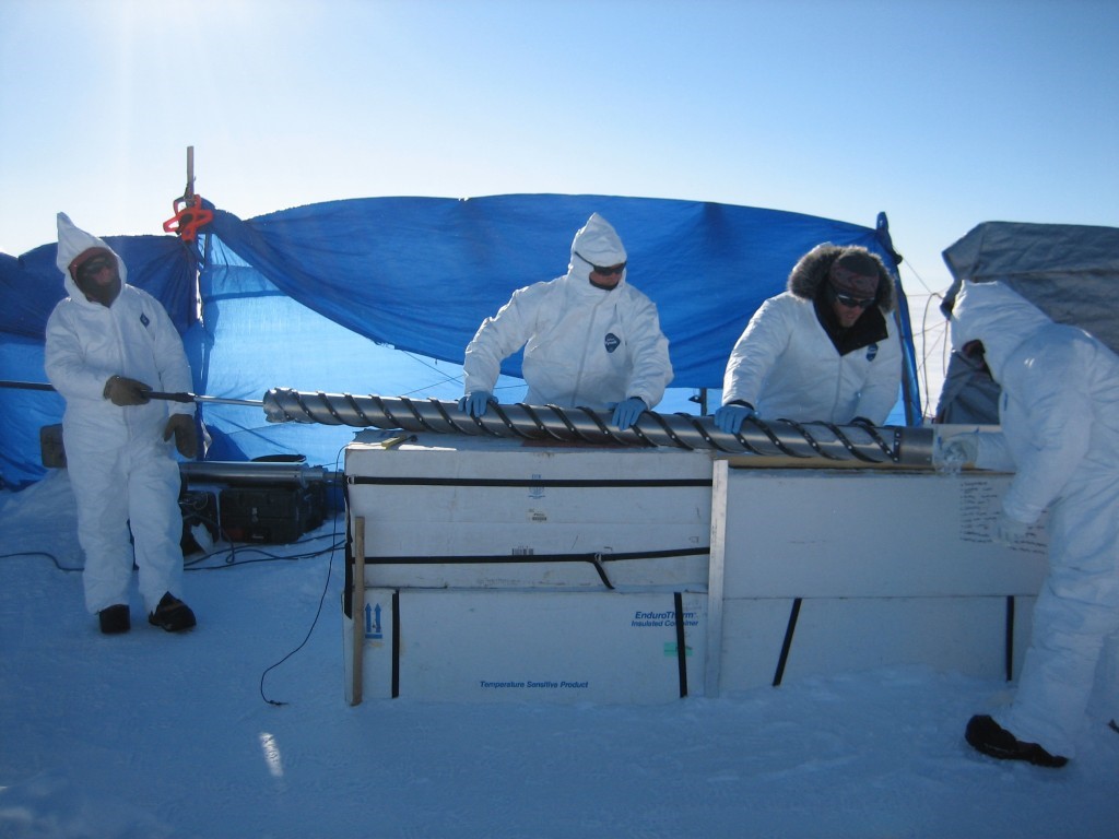


A freshly drilled ice-core from TUNU, Greenland containing a history of volcanic  eruptions is pushed out of the core barell [Credit: Olivia Maselli] 


Tropical volcanoes and large eruptions in the Northern Hemisphere high latitudes (such as Iceland and North America) -- in 536, 626, and 939 CE, for example -- often caused severe and widespread summer cooling in the Northern Hemisphere by injecting sulfate and ash into the high atmosphere. 
These particles also dimmed the atmosphere over Europe to such an extent that the effect was noted and recorded in independent archives by numerous historical eyewitnesses. Climatic impact was strongest and most persistent after clusters of two or more large eruptions. 
The authors note that their findings also resolve a long-standing debate regarding the causes of one of the most severe climate crises in recent human history, starting with an 18-month "mystery cloud" or dust veil observed in the Mediterranean region beginning in March, 536, the product of a large eruption in the high-latitudes of the Northern Hemisphere. 
The initial cooling was intensified when a second volcano located somewhere in the tropics erupted only four years later. In the aftermath, exceptionally cold summers were observed throughout the Northern Hemisphere. 
This pattern persisted for almost fifteen years, with subsequent crop failures and famines -- likely contributing to the outbreak of the Justinian plague that spread throughout the Eastern Roman Empire from 541 to 543 CE, and which ultimately decimated the human population across Eurasia. "This new reconstruction of volcanic forcing will lead to improved climate model simulations through better quantification of the sensitivity of the climate system to volcanic influences during the past 2,500 years," noted Joe McConnell, Ph.D., a DRI research professor who developed the continuous-flow analysis system used to analyze the ice cores. "As a result," McConnell added, "climate variability observed during more recent times can be put into a multi-millennial perspective -- including time periods such as the Roman Warm Period and the times of significant cultural change such as Great Migration Period of the 6th century in Europe." 
This reconciliation of ice-core records and other records of past environmental change will help define the role that large climatic perturbations may have had in the rise and fall of civilizations throughout human history. "With new high-resolution records emerging from ice cores in Greenland and Antarctica, it will be possible to extend this reconstruction of volcanic forcing probably all the way back into the last Ice Age," said Sigl. 


Source: Desert Research Institute [July 08, 2015]

giovedì 10 aprile 2014

Antico impatto

Non è facile immaginare l'asteroide che potrebbe avere eliminato i dinosauri 65 milioni d'anni fa. E' ancora più difficile immaginarne uno ancora più grande (molte volte più grande) che cade sulla terra 3 miliardi e 260 milioni d'anni fa e crea un cratere col diametro corrispondente alla distanza che c'è tra Roma e Milano, causando estesissimi terremoti dell'ordine di 10.8 R. Il tutto è partito da una serie di studi riguardo la Barberton Greenstone belt, una formazione di un centinaio di km per 60 km, sita ad est di Johannesburg. L'impatto - certamente terribile - potrebbe avere modificato le primissime forme di vita del pianeta, distruggendone alcune e salvandone altre. 

Scientists reconstruct ancient impact that dwarfs dinosaur-extinction blast


 Picture this: A massive asteroid almost as wide as Rhode Island and about three to five times larger than the rock thought to have wiped out the dinosaurs slams into Earth. 
The collision punches a crater into the planet's crust that's nearly 500 kilometers (about 300 miles) across: greater than the distance from Washington, D.C. to New York City, and up to two and a half times larger in diameter than the hole formed by the dinosaur-killing asteroid. 
Seismic waves bigger than any recorded earthquakes shake the planet for about half an hour at any one location -- about six times longer than the huge earthquake that struck Japan three years ago. The impact also sets off tsunamis many times deeper than the one that followed the Japanese quake. 


A graphical representation of the size of the asteroid thought to have killed the dinosaurs, and the crater it created, compared to an asteroid thought to have hit the Earth 3.26 billion years ago and the size of the crater it may have generated. A new study reveals the power and scale of the event some 3.26 billion years ago which scientists think created geological features found in a South African region known as the Barberton greenstone belt [Credit: American Geophysical Union] 


Although scientists had previously hypothesized enormous ancient impacts, much greater than the one that may have eliminated the dinosaurs 65 million years ago, now a new study reveals the power and scale of a cataclysmic event some 3.26 billion years ago which is thought to have created geological features found in a South African region known as the Barberton greenstone belt
The research has been accepted for publication in Geochemistry, Geophysics, Geosystems, a journal of the American Geophysical Union. The huge impactor -- between 37 and 58 kilometers (23 to 36 miles) wide -- collided with the planet at 20 kilometers per second (12 miles per second). 
The jolt, bigger than a 10.8 magnitude earthquake, propelled seismic waves hundreds of kilometers through Earth, breaking rocks and setting off other large earthquakes. Tsunamis thousands of meters deep -- far bigger than recent tsunamis generated by earthquakes -- swept across the oceans that covered most of Earth at that time. 
"We knew it was big, but we didn't know how big," Donald Lowe, a geologist at Stanford University and a co-author of the study, said of the asteroid. 
Lowe, who discovered telltale rock formations in the Barberton greenstone a decade ago, thought their structure smacked of an asteroid impact. The new research models for the first time how big the asteroid was and the effect it had on the planet, including the possible initiation of a more modern plate tectonic system that is seen in the region, according to Lowe. 
The study marks the first time scientists have mapped in this way an impact that occurred more than 3 billion years ago, Lowe added, and is likely one of the first times anyone has modeled any impact that occurred during this period of Earth's evolution. The impact would have been catastrophic to the surface environment. 
The smaller, dino-killing asteroid crash is estimated to have released more than a billion times more energy than the bombs that destroyed Hiroshima and Nagasaki. 
The more ancient hit now coming to light would have released much more energy, experts said.
 The sky would have become red hot, the atmosphere would have been filled with dust and the tops of oceans would have boiled, the researchers said. The impact sent vaporized rock into the atmosphere, which encircled the globe and condensed into liquid droplets before solidifying and falling to the surface, according to the researchers. 
The impact may have been one of dozens of huge asteroids that scientists think hit Earth during the tail end of the Late Heavy Bombardment period, a major period of impacts that occurred early in Earth's history -- around 3 billion to 4 billion years ago. 
Many of the sites where these asteroids landed were destroyed by erosion, movement Earth's crust and other forces as Earth evolved, but geologists have found a handful of areas in South Africa, and Western Australia that still harbor evidence of these impacts that occurred between 3.23 billion and 3.47 billion years ago.
 The study's co-authors think the asteroid hit Earth thousands of kilometers away from the Barberton Greenstone Belt, although they can't pinpoint the exact location. "We can't go to the impact sites. 
In order to better understand how big it was and its effect we need studies like this," said Lowe. Scientists must use the geological evidence of these impacts to piece together what happened to the Earth during this time, he said. The study's findings have important implications for understanding the early Earth and how the planet formed. The impact may have disrupted Earth's crust and the tectonic regime that characterized the early planet, leading to the start of a more modern plate tectonic system, according to the paper's co-authors. 
The pummeling the planet endured was "much larger than any ordinary earthquake," said Norman Sleep, a physicist at Stanford University and co-author of the study. He used physics, models, and knowledge about the formations in the Barberton greenstone belt, other earthquakes and other asteroid impact sites on Earth and the moon to calculate the strength and duration of the shaking that the asteroid produced. Using this information, Sleep recreated how waves traveled from the impact site to the Barberton greenstone belt and caused the geological formations. The geological evidence found in the Barberton that the paper investigates indicates that the asteroid was "far larger than anything in the last billion years," said Jay Melosh, a professor at Purdue University in West Lafayette, Indiana, who was not involved in the research. 
The Barberton greenstone belt is an area 100 kilometers (62 miles) long and 60 kilometers (37 miles) wide that sits east of Johannesburg near the border with Swaziland. It contains some of the oldest rocks on the planet. 
The model provides evidence for the rock formations and crustal fractures that scientists have discovered in the Barberton greenstone belt, said Frank Kyte, a geologist at UCLA who was not involved in the study. "This is providing significant support for the idea that the impact may have been responsible for this major shift in tectonics," he said. Reconstructing the asteroid's impact could also help scientists better understand the conditions under which early life on the planet evolved, the paper's authors said. 
Along with altering Earth itself, the environmental changes triggered by the impact may have wiped out many microscopic organisms living on the developing planet, allowing other organisms to evolve, they said. "We are trying to understand the forces that shaped our planet early in its evolution and the environments in which life evolved," Lowe said. 


Source:  American Geophysical Union [April 09, 2014] 

Read more at: http://archaeologynewsnetwork.blogspot.it/2014/04/scientists-reconstruct-ancient-impact.html?utm_source=feedburner&utm_medium=feed&utm_campaign=Feed:+TheArchaeologyNewsNetwork+(The+Archaeology+News+Network)#.U0bg2Sh7DfV
Follow us: @ArchaeoNewsNet on Twitter | groups/thearchaeologynewsnetwork/ on Facebook 

sabato 30 novembre 2013

Supervulcano in Piemonte

Italian fossil supervolcano highlighted in new UNESCO Geopark


Piedmont territory in northwest Italy is designated geopark backed by 80 Alpine communities. Area is an important geological and cultural locale that promotes awareness of earth sciences and sustainable use of resources.

Italian fossil supervolcano highlighted in new UNESCO Geopark
The 'Sesia Valley Grande geopark', a project of the Val Grande National Park and the association Supervolcano Sesia Valley, was officially approved by the World Conference on Geoparks: the protected area thus becomes part of the World Network of Geoparks UNESCO [Credit: La Stampa]
“It is a rare event that geology is a catalyst of public cooperation and celebration,” says geologist and volcano expert James E. Quick, Southern Methodist University, Dallas.

The new Sesia-Val Grande Geopark is an example of just that, says Quick, whose international team in 2009 discovered a fossil supervolcano that now sits at the heart of the new geopark. The discovery sparked worldwide scientific interest and a regional geotourism industry.

Recently designated a geopark by the United Nations Educational, Scientific and Cultural Organization (UNESCO), the Sesia-Val Grande Geopark encompasses more than 80 communities in the Italian Alps.

The communities joined forces more than two years ago to promote the park’s creation, which UNESCO made official in September. The geopark spans tens of thousands of acres and has at its center the massive, 282 million-year-old fossil supervolcano.

Italian fossil supervolcano highlighted in new UNESCO Geopark
“Sesia Valley is unique,” said Quick. “The base of the Earth’s crust is turned up on edge, exposing the volcano’s plumbing — which normally extends deep into the Earth and out of sight. The uplift was created when Africa and Europe began colliding about 30 million years ago and the crust of Italy was turned on end. We call this fossil the ‘Rosetta Stone’ for supervolcanoes because the depth to which rocks are exposed will aid scientific understanding of one of nature’s most massive and violent events and help us to link the geologic and geophysical data.”

The fossil supervolcano was discovered by Quick’s scientific team, which included scientists from Italy’s University of Trieste. The supervolcano has an unprecedented 15 miles of volcano plumbing exposed from the surface to the source of the magma deep within the Earth. Previously, the discovery record for exposed plumbing was about three miles, said Quick.

Located in the Piedmont region of northwest Italy, the geopark also includes Val Grande National Park, the largest wilderness area in Italy. Sesia Valley and Val Grande are important historical and cultural locales.

Only a handful of locations worldwide are chosen annually for UNESCO’s coveted geopark designation, which supports national geological heritage initiatives.

Geoparks promote awareness of the earth sciences, including natural hazards and sustainable use of resources. Worldwide, there are now 100 geoparks. Sesia-Val Grande is Italy’s ninth.

Sesia-Val Grande area is popular for diverse geology, culture, ecosystems

Community cooperation is new to this part of the Alps, where villages have valued their independence for centuries and residents in adjacent valleys may speak distinct dialects. In the wake of the supervolcano discovery, the communities in Val Sesia and Val Grande joined in an unprecedented partnership to promote tourism, education and a collective identity, then applied to UNESCO for admission to the Global Geopark Network.

Italian fossil supervolcano highlighted in new UNESCO Geopark
The  'Sesia Valley Grande geopark' features hiking trails, areas of geological significance and pristine forests visited each year by scholars and researchers from universities around the world [Credit: La Stampa]
Delineated by two neighboring Alpine valleys in northwest Italy, the territory of the geopark is a well-established tourist region that is popular for its wine, cheese, quarried marble, cultural heritage spanning thousands of years, hiking, skiing, rafting, biking and climbing.

The area is about half the size of Rhode Island and has 153,000 residents. Its four environmentally diverse ecosystems are rich in biodiversity and diverse microhabitats, progressing from lowland agricultural prairies to expansive forests to Alpine peaks, the highest of which is 15,203-foot Monte Rosa in one of Europe’s largest ski resorts.

Supervolcano was cataclysmic eruption, set off catastrophic global cooling events

The Sesia Valley supervolcano is a vast rocky expanse, in some places visible in plain sight and in others hidden by forests or under young sedimentary deposits. The supervolcano extends over a third of the Sesia-Val Grande geopark’s territory, said Quick, who previously served as program coordinator for the Volcano Hazards Program of the U.S. Geological Survey.


Italian fossil supervolcano highlighted in new UNESCO Geopark
The supervolcano was active for about 6 million years, beginning about 288 million years ago, Quick said. Its volcanic activity culminated 282 million years ago with an eruption that left an enormous crater measuring more than eight miles in diameter. The cataclysmic eruption released gas from molten rock or “magma,” raining down particles and gases measuring more than 186 cubic miles in volume, Quick has estimated. His team reported the discovery in the scientific journal “Geology” in a 2009 article.

Throughout Earth’s geologic time, supervolcanoes have spread lava and ash vast distances. Scientists believe the fallout may have set off catastrophic global cooling events at different periods in the Earth’s past.

“We want to use this discovery. It can help us understand the fundamental processes that influence eruptions: Where are magmas stored prior to these giant eruptions? From what depth do the eruptions emanate?” Quick said.

Sesia Valley’s unprecedented exposure of magmatic plumbing provides a model for interpreting geophysical profiles and magmatic processes beneath active calderas, he said. The exposure also serves as direct confirmation of the cause-and-effect link between molten rock moving through the Earth’s crust and explosive volcanism.

“It might lead to a better interpretation of monitoring data and improved prediction of eruptions,” said Quick, who is a professor in the SMU Roy M. Huffington Department of Earth Sciences and SMU associate vice president for research and dean of graduate studies.

Source: Southern Methodist University [November 25, 2013]

lunedì 9 settembre 2013

Il più grande vulcano della terra è nel Pacifico

Scientists confirm existence of 

largest single volcano on Earth

A University of Houston (UH) professor led a team of scientists to uncover the largest single volcano yet documented on Earth. Covering an area roughly equivalent to the British Isles or the state of New Mexico, this volcano, dubbed the Tamu Massif, is nearly as big as the giant volcanoes of Mars, placing it among the largest in the Solar System.

Scientists confirm existence of largest single volcano on Earth
3D image of the seafloor showing the size and shape of Tamu Massif, a huge feature
in the northern Pacific Ocean, recently confirmed to be the largest single
volcano on Earth [Credit: Will Sager/University of Houston]
William Sager, a professor in the Department of Earth and Atmospheric Sciences at UH, first began studying the volcano about 20 years ago at Texas A&M's College of Geosciences. Sager and his team's findings appear in the Sept. 8 issue of Nature Geoscience, the monthly multi-disciplinary journal reflecting disciplines within the geosciences.

Located about 1,000 miles east of Japan, Tamu Massif is the largest feature of Shatsky Rise, an underwater mountain range formed 130 to 145 million years ago by the eruption of several underwater volcanoes. Until now, it was unclear whether Tamu Massif was a single volcano, or a composite of many eruption points. By integrating several sources of evidence, including core samples and data collected on board the JOIDES Resolution research ship, the authors have confirmed that the mass of basalt that constitutes Tamu Massif did indeed erupt from a single source near the center.

"Tamu Massif is the biggest single shield volcano ever discovered on Earth," Sager said. "There may be larger volcanoes, because there are bigger igneous features out there such as the Ontong Java Plateau, but we don't know if these features are one volcano or complexes of volcanoes."

Tamu Massif stands out among underwater volcanoes not just for its size, but also its shape. It is low and broad, meaning that the erupted lava flows must have traveled long distances compared to most other volcanoes on Earth. The seafloor is dotted with thousands of underwater volcanoes, or seamounts, most of which are small and steep compared to the low, broad expanse of Tamu Massif.

Scientists confirm existence of largest single volcano on Earth
Analysis of Tamu Massif's core show it formed around 140 million
years ago [Credit: University of Houston]
"It's not high, but very wide, so the flank slopes are very gradual," Sager said. "In fact, if you were standing on its flank, you would have trouble telling which way is downhill. We know that it is a single immense volcano constructed from massive lava flows that emanated from the center of the volcano to form a broad, shield-like shape. Before now, we didn't know this because oceanic plateaus are huge features hidden beneath the sea. They have found a good place to hide."

Tamu Massif covers an area of about 120,000 square miles. By comparison, Hawaii's Mauna Loa -- the largest active volcano on Earth -- is approximately 2,000 square miles, or roughly 2 percent the size of Tamu Massif. To find a worthy comparison, one must look skyward to the planet Mars, home to Olympus Mons. That giant volcano, which is visible on a clear night with a good backyard telescope, is only about 25 percent larger by volume than Tamu Massif.

The study relies on two distinct, yet complementary, sources of evidence -- core samples collected on Integrated Ocean Drilling Program (IODP) Expedition 324 (Shatsky Rise Formation) in 2009, and seismic reflection data gathered on two separate expeditions of the R/V Marcus G. Langseth in 2010 and 2012. The core samples, drilled from several locations on Tamu Massif, showed that thick lava flows (up to 75 feet thick), characterize this volcano. Seismic data from the R/V Langseth cruises revealed the structure of the volcano, confirming that the lava flows emanated from its summit and flowed hundreds of miles downhill into the adjacent basins.

According to Sager, Tamu Massif is believed to be about 145 million years old, and it became inactive within a few million years after it was formed. Its top lies about 6,500 feet below the ocean surface, while much of its base is believed to be in waters that are almost four miles deep.

"It's shape is different from any other sub-marine volcano found on Earth, and it's very possible it can give us some clues about how massive volcanoes can form," Sager said. "An immense amount of magma came from the center, and this magma had to have come from the Earth's mantle. So this is important information for geologists trying to understand how the Earth's interior works."

Source: University of Houston [September 05, 2013]